
 Script Planner Assistant▸
 AI Apps
 AI News

GeoFS: A Free Browser-Based Multiplayer Flight Simulator
GeoFS: A Free Browser-Based Multiplayer Flight SimulatorIntroduction
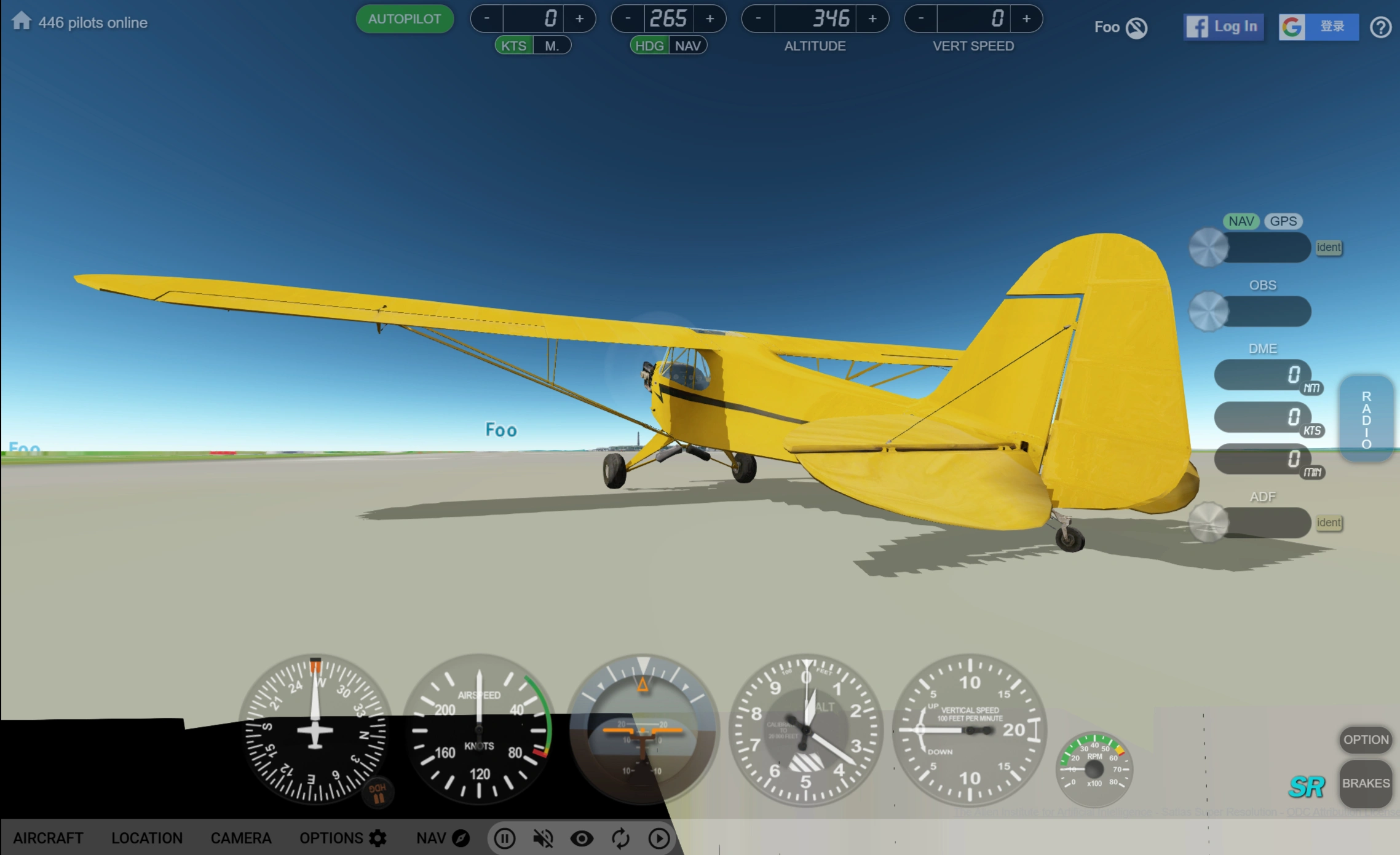
GeoFS is a web-based multiplayer flight simulator that requires no software installation and runs directly in your browser. It supports Windows, Mac, and Linux systems, as well as iOS and Android mobile devices, and is compatible with joystick controls.
Core Features of GeoFS
Basic Features: Free online flight simulation with multiplayer, generating the world from satellite imagery; offers over 30 planes (including community models), supports standard satellite images (10m/pixel), and can be upgraded to high-definition (1m/pixel) imagery through a paid subscription, suitable for VFR practice.
Navigation & Facilities: Provides navigation charts (including 40,000 runways), radio navigation functions (GPS, ADF, VOR, NDB, DME), and supports real-time ADS-B data to display actual commercial flight traffic.
Environment Simulation: Configurable or real-time weather (wind, turbulence, thermals, etc.), supports PAPI and runway lighting for approach assistance, and provides day/night cycle settings along with a lighting system.
Control Methods: Supports keyboard, mouse, and gamepad controls, provides virtual cockpits and a realistic physics engine (simulating lift, drag, and stall).
Social & Learning: Supports multiplayer and Discord community interaction, suitable for use by schools or enterprises through the GeoFS PRO program.
Web Features
Imagery & Scenery: Based on the Cesium virtual globe framework, providing photorealistic scenery.
Map Functions: Includes airspace, traffic, navigation facilities, and runway information, supports waypoint markers (such as takeoff and approach points).
Flight Experience: The physics engine is based on real-world laws, simulating aircraft dynamics; supports real-time display of global commercial flight traffic.
How to Use GeoFS
Basic Requirements
The browser must support WebGL 2.0 (can be tested via webglreport.com). Chrome, Firefox, and other browsers that support the GamePad API are recommended.
Accounts & Controls
Fly anonymously or log in via Facebook/Google to obtain an account (you can set a callsign and enable chat functions).
Keyboard Controls: Up and down arrow keys pitch the aircraft; left and right arrow keys roll the aircraft; "+" and "-" keys (or Page Up and Page Down) increase or decrease throttle; "[" lowers the flaps by one step, "]" raises the flaps by one step; "F" cycles through flap positions; "Home" and "End" increase/decrease elevator trim; "Delete" resets elevator trim; "G" extends/retracts landing gear; "B" extends/retracts airbrakes; "E" starts/stops the engine; Space bar applies brakes; ";" engages/disengages the parking brake; "X" toggles optional animated parts; "Z" toggles attachments (such as floats, water rudders, tailhooks).
Mouse Controls: The mouse acts as a joystick. Press "M" to temporarily disable the mouse (useful when navigating menus and options); press "M" again to re-enable mouse control. Push/pull pitches the aircraft, left/right rolls it (default is mixed with yaw, but configurable). Mouse sensitivity and curves can be configured in the "Options" panel.
Gamepad: Browser controller support requires pressing a button to enable and detect hardware. Active status can be monitored and gamepad axes/buttons assigned under Options > Controls > Gamepad.
Flight Operations
Helicopter: Disable the roll/yaw mixing function in the configuration panel. Throttle controls collective pitch ("+" to ascend, "-" to descend), arrow keys control cyclic pitch, and yaw keys counteract torque.
Hot Air Balloon: Press "Down Arrow" to ignite the burner and take off, and adjust altitude to respond to wind direction changes.
Camera Modes
Six modes are available: Follow (smooth transitions), Cockpit (pilot's view), No Cockpit (no 3D model), Chase (static view), Free (default Cesium camera), and Fixed (attached to the aircraft and rotatable). Some aircraft support additional views (such as cabin or wing).
Switch between these modes via the option bar or by pressing "C".
Flight Destinations
Preset destination selection;
Enter any location in the search box;
Map Mode: Take off from any of over 30,000 runways worldwide, with altitude selection supported (default 1000 feet).
Map Functions
Press the "Nav" button (or the "N" key) to open the map.
Click colored markers (blue for main runways >3000 feet, yellow for small airports) to view runway information and perform "Takeoff", "Fly Over", or "Approach" actions;
Right-click on the map to set flight paths or create GPS FIXes (similar to an unlimited-range VOR);
Displays airspace, navigation facilities (VOR/NDB/DME/ILS), and ADS-B traffic (dark blue for players, light blue for real flights).
Radio Navigation
Click navigation facility icons to view information and tune frequencies (VOR/ILS tune to NAV1, NDB tunes to ADF);
Right-click on a map location to create a GPS FIX (substituting for a NAV frequency), supporting direct flight to a target point with altitude selection;
Tune frequencies via the "RADIO" button or the buttons on the right side of the screen. Press "ident" to listen to the Morse identifier code (during ILS approach, the course is automatically aligned with the runway heading).
Key Questions
Q: What is the difference between the free version and the HD subscription version of GeoFS?
A: The free version provides 10-meter global satellite imagery and contains ads; the HD subscription version (€9.99/year) provides high-definition aerial imagery (suitable for VFR navigation) and is ad-free.
Q: What platforms and devices does GeoFS support?
A: It supports Windows, Mac, and Linux desktop systems, as well as iOS and Android mobile devices, and can run via the web or through an installed mobile app.
Q: How does the multiplayer mode in GeoFS work?
A: After logging in with a Google or Facebook account, you can chat in real time with other pilots, view the online list and join others' flights, and see real commercial flight traffic based on ADS-B data.